Research Portal
A directory of open access Convex Seascape Survey research resources. Here you can download our latest publications and explore our data - from environmental, biological and historical datasets, to maps and photographs, all are uploaded and stored in freely accessible online repositories. We believe in a transparent approach as we advance knowledge in this rapidly-evolving field of blue carbon science.
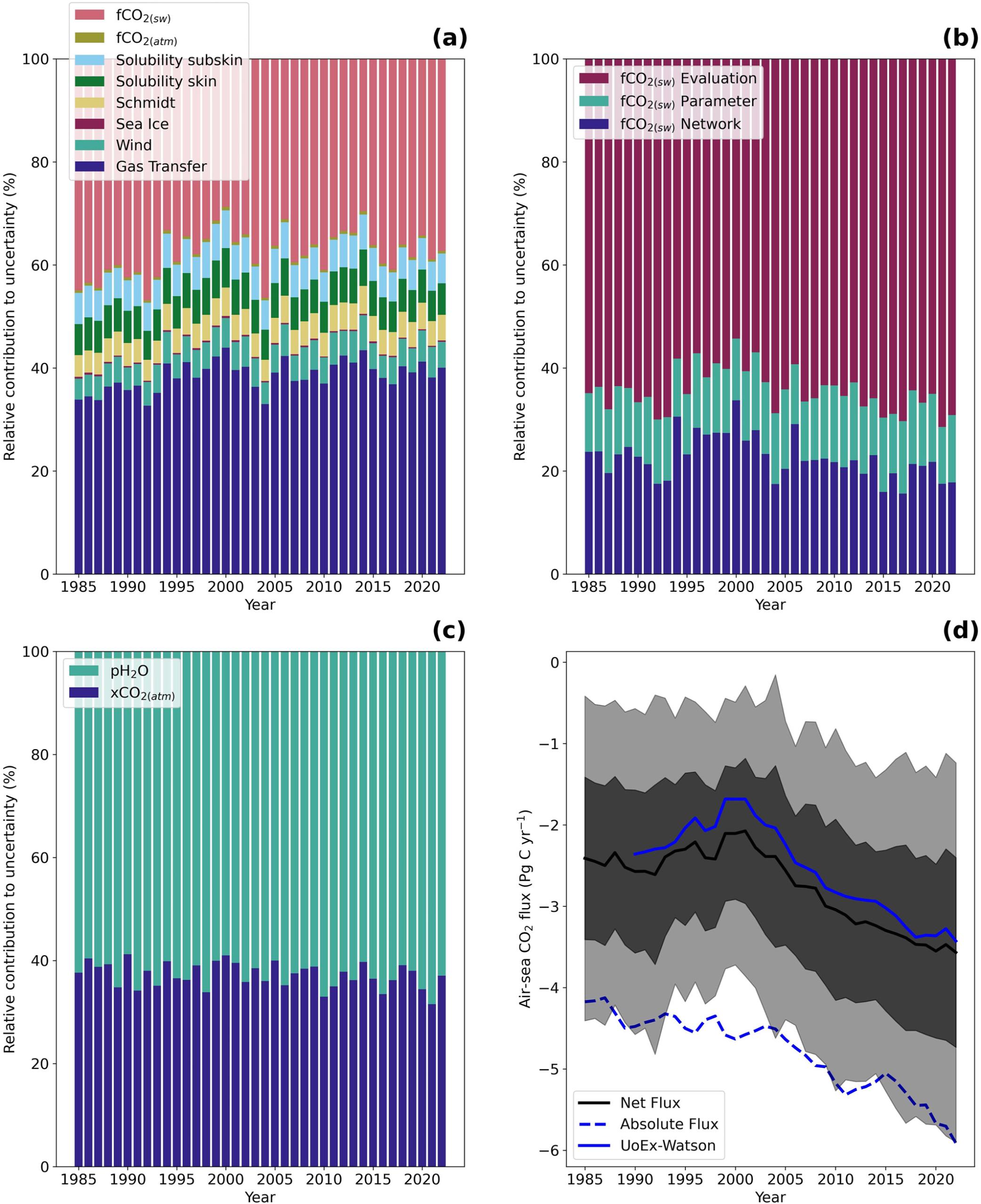
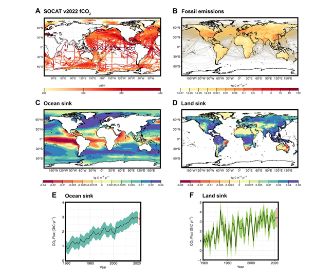
A comprehensive analysis of air-sea CO2 flux uncertainties constructed from surface ocean data products
Increasing anthropogenic CO2 emissions to the atmosphere are partially sequestered into the global oceans through the air-sea exchange of CO2 and its subsequent movement to depth, commonly referred to as the global ocean carbon sink. Quantifying this ocean carbon sink provides a key component for closing the global carbon budget, which is used to inform and guide policy decisions. These estimates are typically accompanied by an uncertainty budget built by selecting what are perceived as critical uncertainty components based on selective experimentation. However, there is a growing realization that these budgets are incomplete and may be underestimated, which limits their power as a…
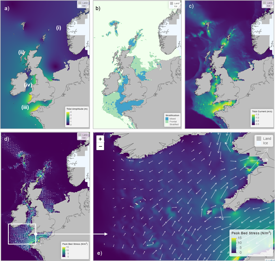
(PALTIDE) for relative sea level and palaeotidal simulations of the northwest European shelf seas since the Last Glacial Maximum
Relative sea level (RSL) predictions based on glacial isostatic adjustment (GIA) simulations and palaeotidal predictions generated by hydrodynamic models using GIA-generated palaeotopographies are available in the published literature, and datasets are available via data repositories. However, these data are often difficult to extract for specific locations or timeslices, requiring users to request datasets from corresponding authors. To overcome the intractability of these data and to enable users to interrogate datasets themselves without requiring offline requests, we have developed PALTIDE, an online visualization tool with intuitive user interface. The model domain for this interactive visualization tool is the…
Advances in understanding of air–sea exchange and cycling of greenhouse gases in the upper ocean
The air–sea exchange and oceanic cycling of greenhouse gases (GHG), including carbon dioxide (CO2), nitrous oxide (N2O), methane (CH4), carbon monoxide (CO), and nitrogen oxides (NOx = NO + NO2), are fundamental in controlling the evolution of the Earth’s atmospheric chemistry and climate. Significant advances have been made over the last 10 years in understanding, instrumentation and methods, as well as deciphering the production and consumption pathways of GHG in the upper ocean (including the surface and subsurface ocean down to approximately 1000 m). The global ocean under current conditions is now well established as a major sink for CO2, a major source for N2O and a minor source for both…
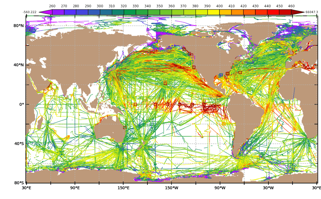
Reanalysed (depth and temperature consistent) surface ocean CO₂ atlas (SOCAT) version 2022 (v2022-0)
The Surface Ocean CO₂ Atlas (SOCAT) version 2022 dataset (Bakker et al., 2016;) is a quality-controlled dataset containing 33.7 million surface ocean gaseous CO₂ measurements collated from thousands of individual submissions. These gaseous CO₂ measurements are typically collected at many different depths (of the order of several metres below the surface) using many different systems, and the sampling depth varies dependent upon the sampling platform and/or setup. Different platforms (e.g. ships of opportunity, research vessels) and systems will collect water samples at different depths, and the sampling depth can even vary dependent upon sea state. Therefore, the collated SOCAT…